Rio Grande Wild and Scenic River
In this article, we will explore the fascinating world of Rio Grande Wild and Scenic River. From its origins to its impact on today's society, we will immerse ourselves in a detailed analysis that will allow us to understand its importance in different areas. Rio Grande Wild and Scenic River has been the subject of interest and debate over time, its implications have transcended cultural and generational barriers. Through this journey, we will seek to unravel the mysteries and curiosities surrounding Rio Grande Wild and Scenic River, in an attempt to shed light on its relevance in the current context.
| Rio Grande Wild and Scenic River | |
|---|---|
IUCN category V (protected landscape/seascape) | |
 Rio Grande - Wild and Scenic River | |
  | |
| Location | New Mexico and Texas |
| Coordinates | 29°29′0″N 103°18′0″W / 29.48333°N 103.30000°W |
| Area | 9,600 acres |
| Established | October 2, 1968 |
| Governing body | Bureau of Land Management, United States Forest Service, National Park Service |
| Website | Rio Grande Wild and Scenic River |
| Type | Wild 150.1 miles (241.6 km) Scenic 108.5 miles (174.6 km) Recreational 0.8 miles (1.3 km) |
| Designated | October 2, 1968 |
The Rio Grande Wild and Scenic River is a U.S. National Wild and Scenic River that protects 260 miles (420 km) of the Rio Grande in New Mexico and Texas, in the United States. The designation was first applied in 1968 to a 55.7-mile (89.6 km) stretch of the river in New Mexico; an additional 191.2 miles (307.7 km) of the river in Texas was added in 1978, followed by another 12.5 miles (20.1 km) in New Mexico in 1994.
The New Mexico portion of the Wild and Scenic River runs from the New Mexico–Colorado border approximately 68 miles (109 km) south. The lower 4 miles (6 km) of the Red River, a tributary of the Rio Grande in Taos County, New Mexico, was also added to the Wild and Scenic River System. The two rivers intersect in the Wild Rivers Recreation Area.
Approximately 69 miles (111 km) of the Wild and Scenic River in Texas is within Big Bend National Park; the remainder is downstream of Big Bend. Three rugged canyons are preserved under this designation: Boquillas Canyon is the most accessible, as it can be reached via a popular RV campground; Mariscal Canyon can only be entered via a high-clearance four-wheel-drive vehicle; and entrance to the Lower Canyon, due to rapid size, is only possible by signing a National Park Service liability or "acknowledgement of risk" waiver. The Wild and Scenic River designation does not include Santa Elena Canyon, which is the most popular recreational area in Big Bend.
Gallery
-
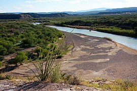 Rio Grande Bend near Boquillas Canyon

See also
References
- ^ "National Wild and Scenic Rivers System" (PDF). rivers.gov. National Wild and Scenic Rivers System. Retrieved 2023-01-05.
External links
 Media related to Rio Grande at Wikimedia Commons
- Rio Grande Wild and Scenic River - National Park Service
- Rio Grande Wild and Scenic River - Bureau of Land Management
This article related to a protected area in Texas is a stub. You can help Wikipedia by expanding it. |
This National Park Service related article is a stub. You can help Wikipedia by expanding it. |