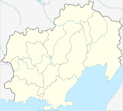
Kholodny, Magadan Oblast
In this article we will explore the topic of Kholodny, Magadan Oblast from different perspectives and approaches, with the aim of providing a comprehensive and complete vision of this topic. Throughout the text, we will analyze both its origins and its relevance today, as well as its possible implications and consequences. Likewise, we will examine different studies and research that have been carried out around Kholodny, Magadan Oblast, in order to offer an academic and scientifically based vision. Ultimately, this article seeks to provide the reader with a deep and detailed insight into Kholodny, Magadan Oblast, so that they can acquire solid and complete knowledge on the subject.
Kholodny
Холодный | |
|---|---|
| Coordinates: 62°42′48″N 147°54′45″E / 62.7134°N 147.9124°E | |
| Country | Russia |
| Federal subject | Magadan Oblast |
| Administrative district | Susumansky District |
| Population | |
| • Total | 1,062 |
| • Estimate | 837 (−21.2%) |
| Time zone | UTC+11 (MSK+8 |
| Postal code(s) | |
| OKTMO ID | 44713000056 |
Kholodny (Russian: Холо́дный) is an urban-type settlement in Magadan Oblast, Russia. Population: 1,062 (2010 Russian census); 1,344 (2002 Census); 1,826 (1989 Soviet census).
Geography
Kholodny is located around 380 km north-north-west of the city of Magadan, by the Byoryolyokh river in the Upper Kolyma Highlands. It is in Susumansky District, 14 km from the administrative centre Susuman.
History
The settlement was founded in 1941 as a gold mining base, gaining urban-type settlement status in 1962. The settlement's name Kholodny is the Russian word for cold.
Infrastructure
Kholodny lies on the Kolyma Highway.
References
- ^ a b Russian Federal State Statistics Service (2011). Всероссийская перепись населения 2010 года. Том 1 [2010 All-Russian Population Census, vol. 1]. Всероссийская перепись населения 2010 года (in Russian). Federal State Statistics Service.
- ^ "26. Численность постоянного населения Российской Федерации по муниципальным образованиям на 1 января 2018 года". Federal State Statistics Service. Retrieved 23 January 2019.
- ^ "Об исчислении времени". Официальный интернет-портал правовой информации (in Russian). 3 June 2011. Retrieved 19 January 2019.
- ^ Почта России. Информационно-вычислительный центр ОАСУ РПО. (Russian Post). Поиск объектов почтовой связи (Postal Objects Search) (in Russian)
- ^ Federal State Statistics Service (21 May 2004). Численность населения России, субъектов Российской Федерации в составе федеральных округов, районов, городских поселений, сельских населённых пунктов – районных центров и сельских населённых пунктов с населением 3 тысячи и более человек [Population of Russia, Its Federal Districts, Federal Subjects, Districts, Urban Localities, Rural Localities—Administrative Centers, and Rural Localities with Population of Over 3,000] (XLS). Всероссийская перепись населения 2002 года (in Russian).
- ^ Всесоюзная перепись населения 1989 г. Численность наличного населения союзных и автономных республик, автономных областей и округов, краёв, областей, районов, городских поселений и сёл-райцентров [All Union Population Census of 1989: Present Population of Union and Autonomous Republics, Autonomous Oblasts and Okrugs, Krais, Oblasts, Districts, Urban Settlements, and Villages Serving as District Administrative Centers]. Всесоюзная перепись населения 1989 года (in Russian). Институт демографии Национального исследовательского университета: Высшая школа экономики . 1989 – via Demoscope Weekly.


