
Kruishoutem
In this article, we will delve into the fascinating world of Kruishoutem, exploring its different facets, characteristics and possible implications in various areas. From its origin to its relevance today, we will delve into a detailed analysis that will allow us to understand its importance and influence on society. Through studies, interviews and concrete examples, we will seek to shed light on Kruishoutem and its impact on the contemporary world, offering the reader a complete and enriching vision of this exciting topic.
Kruishoutem | |
|---|---|
Village and former municipality | |
 Street view | |
 Flag  Seal | |
 Kruishoutem Location in Belgium | |
| Coordinates: 50°54′N 03°31′E / 50.900°N 3.517°E | |
| Country | |
| Region | Flemish Region |
| Province | East Flanders |
| Arrondissement | Oudenaarde |
| Municipality | Kruisem |
| Area | |
• Total | 27.24 km2 (10.52 sq mi) |
| Population (2021)[1] | |
• Total | 5,394 |
| • Density | 198.0/km2 (512.9/sq mi) |
| Time zone | CET |
| Postal code | 9770-9772 |
| Dialing code | 09 |
| Website | www |
Kruishoutem (Dutch: [krœysˈɦʌutəm]; French: Cruyshautem, also used in English) is a village and was a municipality located in the Belgian province of East Flanders. The municipality comprised the towns of Kruishoutem proper, Nokere and Wannegem-Lede. In January 2018, the municipality of Kruishoutem had a total population of 8,086. The total area is 46.76 km2.[2] On 1 January 2019, Kruishoutem and Zingem merged into the new municipality of Kruisem.
The SONS Museum is located in Kruisem.
Notable people
- Charles Louis Spilthoorn (Spilthooren), born 12 October 1804 in Kruishoutem; died 12 September 1872 in Brussels, lawyer and politician.
- Henry Gabriëls, born in Wannegem-Lede on 6 October 1838, professor & rector in Saint Joseph's Seminary in Troy, New York; bishop of Ogdensburg, New York, until his death in 1921. Created Sanatorium Gabriels and town Gabriels, New York.[3]
- Adolf Daens, priest in Kruishoutem in 1878–1879, later member of the Parliament.
Gallery
-
 Church of Nokere
 -
 Town hall
 -
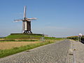 Windmill Schietsjampettermolen
 -
 Pub in Kruishoutem


References
- ^ a b "Bevolking per statistische sector - Sector 45017A". Statistics Belgium. Retrieved 6 May 2022.
Kruishoutem only
- ^ ""Wettelijke Bevolking per gemeente op 1 januari 2018"". StatBel. Retrieved 9 March 2019.
- ^ "Historical sketch of St. Joseph's provincial seminary, Troy, N.Y. | WorldCat.org". search.worldcat.org. Retrieved 25 June 2025.
External links
 Media related to Kruishoutem at Wikimedia Commons
- Official website (in Dutch)
Places adjacent to Kruishoutem | ||||||||||||||||
|---|---|---|---|---|---|---|---|---|---|---|---|---|---|---|---|---|
| ||||||||||||||||
Belgian municipality Kruisem | |
|---|---|
| Deelgemeentes | |
| Buildings and sights | |
| International | |
|---|---|
| Geographic | |
| Other | |
This East Flanders location article is a stub. You can help Wikipedia by expanding it. |