Mohawk River (New Hampshire)
In the article below, we will explore the fascinating world of Mohawk River (New Hampshire). From its origins to its impact today, we will dive into a wide range of aspects related to Mohawk River (New Hampshire). Through a deep and detailed analysis, we will examine its implications in various areas, from society to popular culture. Throughout these pages, we will discover new perspectives and reflections that will allow us to better understand the importance of Mohawk River (New Hampshire) in the contemporary world. With a critical and enriching look, this article seeks to open paths towards a greater understanding and appreciation of Mohawk River (New Hampshire).
| Mohawk River | |
|---|---|
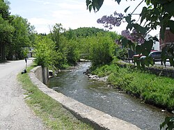
 The Mohawk River entering Colebrook | |
| Location | |
| Country | United States |
| State | New Hampshire |
| County | Coos |
| Towns | Dixville, Colebrook |
| Physical characteristics | |
| Source | Lake Gloriette |
| • location | Dixville Notch |
| • coordinates | 44°52′02″N 71°18′27″W / 44.86728°N 71.30752°W |
| • elevation | 1,846 ft (563 m) |
| Mouth | Connecticut River |
• location | Colebrook |
• coordinates | 44°54′02″N 71°30′17″W / 44.9006°N 71.5047°W |
• elevation | 995 ft (303 m) |
| Length | 13.8 mi (22.2 km) |
| Basin features | |
| Tributaries | |
| • left | Roaring Brook |
| • right | Moose Brook, West Branch, Read Brook, Beaver Brook |
The Mohawk River is a 13.8-mile-long (22.2 km) river in northern New Hampshire in the United States. It is a tributary of the Connecticut River, which flows south to Long Island Sound, an arm of the Atlantic Ocean.
The Mohawk River rises at the outlet of Lake Gloriette in Dixville Notch and flows west-northwest to the Connecticut River in the town of Colebrook. It is paralleled for most of its length by New Hampshire Route 26.
See also
References

