Saint-Morel
This article will address the topic of Saint-Morel, which is of great relevance today. Saint-Morel has captured the attention of many due to its impact on various aspects of society, culture and the world in general. Over the years, there has been growing interest and debate surrounding Saint-Morel, leading to further study and research on this topic. This article will analyze different perspectives, data and opinions in order to provide a broad and complete overview of Saint-Morel.
You can help expand this article with text translated from the corresponding article in French. (December 2008) Click for important translation instructions.
|
Saint-Morel | |
|---|---|
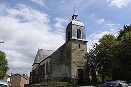
 The church in Saint-Morel | |
| Coordinates: 49°20′18″N 4°41′42″E / 49.3383°N 4.695°E | |
| Country | France |
| Region | Grand Est |
| Department | Ardennes |
| Arrondissement | Vouziers |
| Canton | Attigny |
| Intercommunality | Argonne Ardennaise |
| Government | |
| • Mayor (2020–2026) | Thierry Deglaire |
| Area 1 | 12.04 km2 (4.65 sq mi) |
| Population | 185 |
| • Density | 15/km2 (40/sq mi) |
| Time zone | UTC+01:00 (CET) |
| • Summer (DST) | UTC+02:00 (CEST) |
| INSEE/Postal code | 08392 /08400 |
| Elevation | 122 m (400 ft) |
| 1 French Land Register data, which excludes lakes, ponds, glaciers > 1 km2 (0.386 sq mi or 247 acres) and river estuaries. | |
Saint-Morel (French pronunciation: [sɛ̃ mɔʁɛl]) is a commune in the Ardennes department, region of Grand Est (formerly Champagne-Ardenne), northern France.
Population
| Year | Pop. | ±% |
|---|---|---|
| 1962 | 228 | — |
| 1968 | 259 | +13.6% |
| 1975 | 198 | −23.6% |
| 1982 | 212 | +7.1% |
| 1990 | 235 | +10.8% |
| 1999 | 227 | −3.4% |
| 2008 | 238 | +4.8% |
See also
References
- ^ "Répertoire national des élus: les maires". data.gouv.fr, Plateforme ouverte des données publiques françaises (in French). 2 December 2020.
- ^ "Populations légales 2021" (in French). The National Institute of Statistics and Economic Studies. 28 December 2023.
Wikimedia Commons has media related to Saint-Morel.


