Valle de los Ríos Apurímac, Ene y Mantaro
In today's world, Valle de los Ríos Apurímac, Ene y Mantaro has become a topic of great relevance and interest to a wide variety of people. From experts in the field to the general public, the importance of Valle de los Ríos Apurímac, Ene y Mantaro cannot be underestimated. Over the years, Valle de los Ríos Apurímac, Ene y Mantaro has been the subject of debate, research and analysis in numerous contexts, reflecting its significant impact in various areas of society. In this article, we will explore the different facets of Valle de los Ríos Apurímac, Ene y Mantaro and its influence in today's world, examining its relevance, evolution and the implications it has for the present and the future.


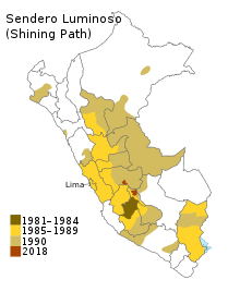
The Valle de los Ríos Apurímac, Ene y Mantaro (lit. 'Valley of the Apurímac, Ene and Mantaro rivers'), also known as the VRAEM, is a geopolitical area in Peru, located in portions of the departments of Ayacucho, Cusco, Huancavelica, and Junin. It is one of the major areas of coca production in Peru. It is also the center of operation of the far-left terrorist group Shining Path.
The area is extremely poor. The VRAEM is an area of such high childhood malnutrition and poverty that the government of Peru selected the VRAEM to launch its National Strategy for Growth program in 2007.
Cocaine production
Since 2012, Peru has overtaken Colombia as the world's largest cocaine-producing country. With local incomes below $10/day, the valleys are used to produce raw paste product, and much of the drug trade is controlled by the Shining Path. With an estimated 19,700 hectares (49,000 acres) of production area (2010), it is presently the world's densest area of cocaine production. Paste product is shipped out of the valleys by armed native backpackers to Cuzco, and then onward shipped to either: the Pacific Ocean ports; the Bolivian border, where it is sold to one of the drug cartels; or to mule-traffickers who ship the product onwards via scheduled air transport to Europe and North America.
See also
References
- ^ a b "Slaves of the past". The Economist. 1 August 2015. Retrieved 3 August 2015.
- ^ "Peru Travel Advisory". travel.state.gov. Retrieved 9 May 2023.
- ^ a b c Pressly, Linda (24 November 2015). "The Mochileros". BBC News. Retrieved 24 November 2015.
- ^ "Crecer ya está en el VRAE". Comisión Interministerial de Asuntos Sociales. 21 December 2007. Retrieved 14 November 2009.
- ^ "Part 5. Peru Coca Cultivation Survey" (PDF). Peru Coca Survey for 2005. United Nations Office on Drugs and Crime. Retrieved 14 November 2009.
- ^ a b c d Archived November 25, 2015, at the Wayback Machine[dead link]
- ^ a b c Collyns, Dan (23 June 2011). "Peru's challenge to tackle cocaine trade". BBC News. Retrieved 26 November 2015.