Van Province
Van Province Van ili | |
|---|---|
 Location of Van Province in Turkey | |
| Kintra | Turkey |
| Region | Eastren Anatolie |
| Govrenment | |
| • Electoral destrict | Van |
| Area | |
| • Tot | 19,069 km2 (7,363 sq mi) |
| Population | |
| • Tot | 1,100,190 |
| • Density | 58/km2 (150/sq mi) |
| Area code(s) | 0432 |
| Vehicle registration | 65 |
Van Province (Turkis: Van ili) is a province in eastren Turkey, atween Lake Van an the Iranian border. It is 19,069 km2 in area an haes a population o 1,035,418.
Its adjacent provinces are Bitlis tae the wast, Siirt tae the soothwast, Şırnak an Hakkâri tae the sooth, an Ağrı tae the north. The caipital is Van (Armenie: Վան Van, Kurdish: Wan). The province an the surroondin area is the hame o famous Van kedisi (Van cat).
On Januar 9, 1990 in Van wis recordit the lawest temperatur in Turkey wi -46.4 °C.
Destricts
Van province is dividit intae 12 destricts (destrict caipitals in bauld):
History
This area wis the hertland o Armenians, who lived in thir areas frae the time o Hayk in the 3rd millennium BC richt up tae the late 19t century when the Ottoman Empire seized aw the land frae the natives. In the 9t century BC the Van area wis the centre o the Urartian kinrick. Frae 7t century BC up tae Islamic conquest o Persians (640 AD), Van haes been unner different Persian dynasties o Merdia, Achaemenids, Arcasids an Sassanids. In 908-1021 wis central pairt o Armenian Kinrick o Vaspurakan, then jynt Byzantine Empire. Wi the Seljuq victory at the Battle o Malazgirt in 1071, juist north o Lake Van, it became a pairt o Seljuq Empire an later the Ottoman Empire. For centuries efter that, the area wis a major Armenian population centre.
Gallery
The neutralitie o this airticle is disputit. |
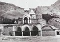
- Medieval Armenie monasteries in the Van Province
-
 The Armenie Cathedral o the Holy Cross (10t c.) on Akhtamar Island
 -
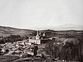 The Armenie Monastery o Narek (10t c.)
 -
 Varagavank Armenie monastery (11t c.)
 -
 The Armenie Monastery o Saunt Bartholomew (13t c.)


See an aa
| Wikimedia Commons haes media relatit tae Van Province. |
Notes
- ↑ Turkish Statistical Institute, MS Excel document – Population of province/district centers and towns/villages and population growth rate by provinces
- ↑ Area codes page of Turkish Telecom website Archived 2011-08-22 at the Wayback Machine (in Turkis)
- ↑ Hofmann (ed.), Tessa (2004). Verfolgung, Vertreibung und Vernichtung der Christen im Osmanischen Reich 1912-1922 . Münster: LIT. ISBN 3-8258-7823-6.CS1 maint: extra text: authors leet (link)
- ↑ European History in a World Perspective - Page 68 by Shepard Bancroft Clough
- ↑ "Archived copy". Archived frae the original on 4 Mairch 2016. Retrieved 2 September 2011.CS1 maint: archived copy as title (link)
Freemit airtins
Coordinates: 38°29′57″N 43°40′13″E / 38.49917°N 43.67028°E
| Urban destricts |   | |
|---|---|---|
| Rural destricts | ||
Regions | ||
| Aegean | ||
| Black Sea | ||
| Central Anatolie | ||
| Eastern Anatolie | ||
| Marmara | ||
| Mediterranean | ||
| Sootheastren Anatolie | ||
| This Turkey-relatit airticle is a stub. Ye can help Wikipaedia bi expandin it. |